|
|
|
|
|
Excursions
|
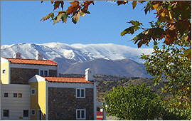
As the house is not too far away from the nearest entrance to the New National Road, from here the whole West of ▶ Crete reveals itself for exploration.
|
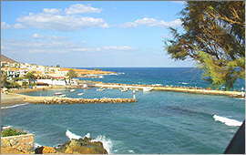
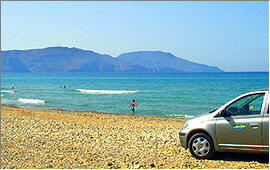
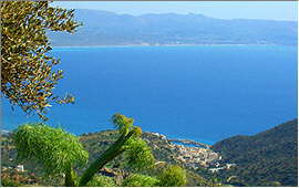
Panormo
is a fishing village on the island's central north coast, belonging to the prefecture of Rethymnon and located 21 kms east of the town. There are some small swimming-bays with sandy beaches west of the port.
|
In former times Panormo was the port of the town of Eleftherna which is 22 kms to the south. Eleftherna which has now been excavated was one of the most important cities of ancient Crete.
In the village center as well as around the port there is a number of apartment facilities, tavernas and shops which have adapted to the needs of a rather relaxed way of tourism.
In the summer the village center is closed to traffic and the tavernas fill the narrow lanes with tables.
|
|
|
Road distance: 9 kms *)
|
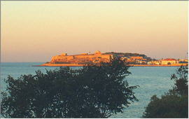
Rethymnon
on Crete's north coast is the capital of the governmental district of the same name.
|
|
|
It ranks as the island's cultural center and gives home to several museums, to the philosopical branch of the University of Crete, and other facilities.
The landmark of Rethymnon is the Fortezza, a fortress from the Venetian aera, standing on an exposed rock that reaches into the bay.
Further inland, the Venetian Old Town attaches to the fortress.
|
In it's crooked lanes there are unnumbered small shops, arts and crafts workshops, restful bars, and restaurants of varied cuisine.
Right below the fortress there is the picturesque Venetian Port which is framed by the modern port's piers.
Every Thursday, the eastern pier also hosts the legendary weekly market of Rethymnon. During the years before, the place changed several times but that could not impair the colourful buzzle at all.
|
|
|
Road distance: 12 kms *)
|
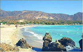
Bali
is a former fishing village on the north coast, at the eastern edge of the governmental district of Rethymnon. It lies at the western flank of a small bay with several sandy beaches, which is framed by mountains.
|
|
|
Close to the port there is a small sandy beach, and several watersports as well as diving are on offer.
A longer beach is located on the south end of the bay near to the newer hotels and apartment facilities.
As the most beautiful beach of Bali ranks however the one which is hidden in a small rocky bay just behind Cape Korakias, which forms the north-western tip of the bay of Bali.
|
Road distance: 19 kms *)
|
Kavros
is a tiny village in the western bay of Rethymnon. Today, the name however also stands for whole coast section between the mouth of Petres creek and the fishing village of Georgioupolis.
|
During thousands of years, the wind and the drift formed an 11 kilometers long sandy beach which towards West becomes wider and wider, and continues under water. It therefore also suits for little children.
By the eastern edge close to the mouth of Petres creek there is a diving center.
Further West by the widest beach section there are some bigger hotel resorts where many watersports are on offer.
|
|
|
Road distance: 29 kms *)
|
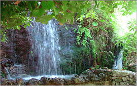
Argiroupolis
stands on the areal of the ancient town of Lappa, above the western bay of Rethymnon some 9 kms South of the coast.
|
|
|
By the lower village border there is a spring with picturesque cascades, which over a distance of 23 kms provides the town of Rethymnon with drinking-water.
The village is a popular destination for excursions as it has typical tavernas (one of them breeding their own trouts), traditional kafenions and bars, a small museum, and fascinating views of the peaceful surroundings, of the White Mountains (Lefka Ori) and the Aegean Sea.
The Lappa excavation site is right next door.
|
Road distance: 34 kms *)
|
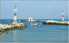
Georgioupolis
is a former fishing-village by the western end of the bay of Rethymnon. Around the old village center, apartment facilities and hotels of any kind and size established themselves, and the old fishing port was extended to a small marina.
|
The landmark of Georgioupolis is a tiny white chapel on the tip of the pier.
In the village center and by the port there is a number of restful cafes and restaurants. The original Mediterranean flair can be felt up to the present day.
During thousands of years, the wind and the drift formed a mile-long sandy beach which continues under water.
It therefore also suits for little children.
|
|
|
Some bigger hotel resorts were built along the bay in eastward direction, and on their beaches all kinds of watersports are on offer.
|
Road distance: 35 kms *)
|
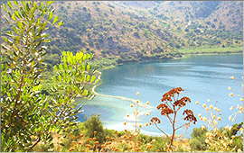
Kournas
is a picturesque and rather sleepy village above the western bay of Rethymnon roughly 7 kms south-east of Georgioupolis.
|
|
|
It is better known because of the Kournas Lake which lies 2 kms below the village and is said to be Crete's only freshwater lake. At least as the only "real" one as it is of natural origin, and has water all-year.
The lake's main spring is close to the southern bank, deep under water. On the northern bank there are some tavernas, and a pedalo rental.
And of course one can have a swim in Lake Kournas: without chlorine, and without salt.
|
Road distance: 36 kms *)
|
Anogia
is one of Crete's highest mountain villages, and besides the biggest one.
|
The people of Anogia were allways highly respected for their musical tradition and all over Crete they have a reputation for their excellent dancers and folkloristic musicians.
Some of the best families of musicians come from Anogia (Xylouris, Skoulas).
A treasure of the village is a tiny private museum that exhibits outstanding objects of the painter and sculptor Alkibiades Skoulas. In his old ages he began to paint the memories of his life.
|
|
|
Being a center for sheep and goat breeding, Anogia is also well known for it's beautiful woven goods.
|
Road distance: 37 kms *)
|
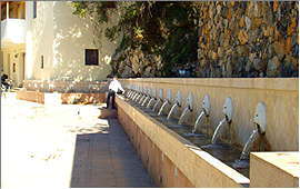
Spili
is a small town counting only approx. 700 inhabitants and belonging to the prefecture of Rethymnon.
|
|
|
It is located some 30 kms south of the city, at 421 meters above sea level. The south shore is just behind the coastal mountains.
The surroundings are composed of particularly exciting landscapes. Mt. Vorisis (878 meters) towers above Spili, and the town itself is said to be most picturesque.
The landmark of Spili is a Venetian style fountain with 25 water-spitting lionheads, and there are even some old houses which originally remain from the Venetian era.
|
Road distance: 43 kms *)
|
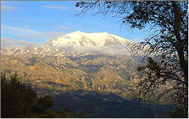
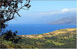
The Valley of Amari
is one of the most scenic ways to approach Crete's central mountain range.
|
It spreads from Prasses (10 kms from Rethymnon on the north coast) in south-east direction to Adopoulou (10 kms from Aghia Galini on the south coast).
Between the two villages of Vizari and Kouroutes, the valley runs in only 7 kms air-line distance below the 5 highest summits of the Ida Massif:
Stolistra / 2,325 m, Timios Stavros / 2,456 m, Angathias / 2,424 m, Vouloumenou / 2,267 m und Koussakas / 2,209 m.
|
|
|
In New Greek language, the Ida Massif is also called "Psiloritis" which means "the tall one".
|
Road distance: 48 kms *)
|
Plakias
is an old fishing-village on the south coast of the district of Rethymnon.
|
|
|
To individual tourists, Plakias is known since some years but still rather untouched by mass tourism.
Around the port and further on eastward along the sandy beach which lines the bay, some smaller hotels and apartment facilities row up.
Down by the beach road there are several restaurants and tavernas, kafenions, small supermarkets and some other shops.
|
Some 1,500 meters West of the village center, the small bay of Souda with it's sandy beach opens.
|
Road distance: 53 kms *)
|
Agia Galini
lies on the south slope of the small Vouvala Massif, which parts the bigger Kedros Massif from the south coast.
|
The most scenic road to Agia Galini runs from Nea Kria Vrisi via Melambes around the summit of Mt. Vouvala (947 meters).
First open views of Mt. Kedros (1,776 meters) which frequently decorates it's summit with a small cloud, and of the Ida Massif (up to 2,456 meters).
Then the road winds down the slope and opens views of the fishing village, it's port, and the entire Messara bay until Matala on the opposite coast.
|
|
|
Right above the port there are some comfortable tavernas and kafenions with typical Mediterranean flair.
|
Road distance: 66 kms *)
|
Agios Pavlos
When leaving the road from to Agia Galini near Kria Vrisi and turning South, one will pass the village of Saktouria and then approach to the Cape Melissa.
|
|
|
Left hand splits a road down to the eastern beach of Agios Pavlos. There are some tavernas with guest rooms, another one with a mini market, and a beach bar.
Right hand a new road leads down to the western beaches. The sand dune is remarkable, and so are the views over the Libyan Sea, towards Preveli, and with good weather conditions even of the White Mountains ("Lefka Ori").
Since 2006, the paved road makes all the dream beaches of this section of the south coast accessible.
|
Triopetra (a.k.a. the beach of Akoumia) is right ahead, and from there the road continues via Agia Paraskevi and Ligres (the beach of Kerames) until Finikas (the palm beach of Preveli).
|
Road distance: 69 kms *)
|
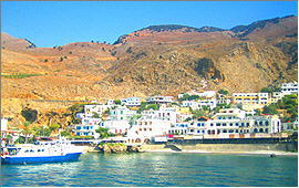
Chora Sfakion
on the first glance gives the impression of a sleepy south coast village where time stands still.
|
Twice per day, things however change when the ferry boat from Paleochora via Sougia and Agia Roumeli arrives.
One can then experience how the infrastructure of Crete was organized during the Minoan Age when country roads did not exist: Ships were steadily travelling around the island and connecting all the bigger and smaller ports and townships.
In the meantime, you can make yourself comfortable in one of the tavernas by the port, and watch cars and trucks assembling for the next boat.
|
|
|
Or you can fit in a side-trip e.g. via Anopoli to Aradena and it's famous valley bridge, or follow the uncounted serpentine bends up to Imbros village which is famous as well, for the pancake with cheese and thyme honey.
|
Road distance: 83 kms *)
|
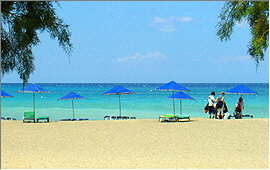
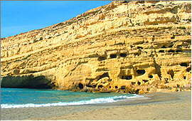
Matala
is famous from the 1960-ies when Hippies from all over the world used to settle here, staying in the caves by the beach.
|
|
|
Today, the caves must not be used for accommodation purposes anymore as they do not fulfill the minimum standard criteria as issued by the Greek Tourism Authority.
Matala his however still worth a visit. It has deep blue sea and a white sandy beach which is framed by yellow rock (with abandoned caves in it).
A blue sky covers the place, and views range over the Messara bay to Agia Galini, to Mt. Kedros, and with clear weather even until the White Mountains ("Lefka Ori").
|
It is easy to understand why they settled right here ...
|
Road distance: 96 kms *)
|
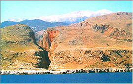
The Gorge of Samaria
begins by the southern edge of the high plateau of Omalos in the White Mountains ("Lefka Ori"), some 42 kms South of Chania.
|
The entrance at 1,127 meters above sea level is called the Wooden Stairs ("Xyloskalo"), and overtowered by Mt. Gingilos (2,080 meters) which ranks as Crete's most beautiful mountain.
A path leads down the 16 kms long gorge, crossing the island's largest nature preserve.
It passes the abandoned village of Samaria, and by the gorge's southern exit the Iron Gate ("Sideroportes") where the rocky walls form a corridor of only 2 meters width.
|
|
|
Another 2 kms South there is the old fishing village of Aghia Roumeli where one can have a swim in the Libyan Sea by the beach of the ancient town of Tarra, or relax in one of the tavernas while waiting for the boat that connects Paleohora and Soughia to Hora Sfakion.
|
Road distance: 111 kms *)
|
Falassarna
is the name of an ancient settlement at Cape Koutri on Crete's west coast, by the sourthern end of the big Gramvoussa peninsula and by the northern edge of the bay of Livadi.
The name today stands for the 3 kms long beach that frames the bay.
|
|
|
The wind from the sea formed it from sandstone, and at some places one can still find some odd remnants of the former sandstone rocks.
The last kilometers of the way to Falassarna are not easy to find. One first has to cross the town of Kastelli Kissamos and to pass it's two ports, until the world seems to end.
After turning left, one will reach the village of Platanos, and will have to search for one of the signs pointing to Falassarna. Some of them are hidden between high grass.
|
The efforts will pay as above the bay, unique views of the sea and the surrounding mountains will open. The beach anyway ranks as one of Crete's finest.
|
Road distance: 130 kms *)
|
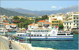
Agios Nicolaos
is the capital of the governmental district of Lassithi which obtains it's name from the high plateau in the district's west, and also includes the two townships of Ierapetra on the south coast and Sitia in the East of the north coast.
|
The town center is located on a small peninsula which spreads eastward into the Mirambelou bay. By the southern edge there is a small fishing port and marina.
The true port of Agios Nicolaos is however located by the peninsula's northern edge. From here, ferry boats travel to Piraeus, Rhodes, Iraklion and Sitia several times per week.
The excursion boats which head towards the former lepers' island of Spinalonga several times per day moor here as well.
|
|
|
|
|
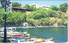
Voulismeni lake which is a small sweetwater lake is located at the side behind the port, and connected to the harbour basin via a channel. It is used as a berth for many small fishing boats.
Around the port and the lake, numerous restaurants, tavernas, kafenions and souvenir shops line up.
Inside the town there are several smaller hotels and apartment houses with a rather private atmosphere.
|
Road distance: 146 kms *)
|
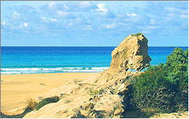
Elafonissi
means "Stag Island". There are no stags on Crete anymore since long, but the small island by the south-western edge of the big island still exists.
|
A reef of red coral connects the two islands, while the neighbouring coastline consists from fine white sand.
The wind and the waves transport plenty of this sand to the top of the reef during springtime, and in late summer at low tide, one can walk from one island to the other on dry foot.
The winter storms will then clean the reef's edges again and allow the corals to continue growing until next year's springtime.
|
|
|
The reef with it's pink edges, the neighbouring white beaches, and the blue sea around make almost a South Sea paradise. Only palm trees are missing, there are shady pine trees instead.
|
Road distance: 153 kms *)
|
*) All data show the shortest respective road distance from Scaleta
|